In the Land of Solitude
Here I am again, Telchac reporting :). This post and a couple more coming will be about a trip I did with a friend of mine. My love, Hojancha, supported me daily throughout the whole trip via satellite phone, even when sometimes only for a minute or two (as it is f$&#ing expensive). At such a place, it meant the world to me.

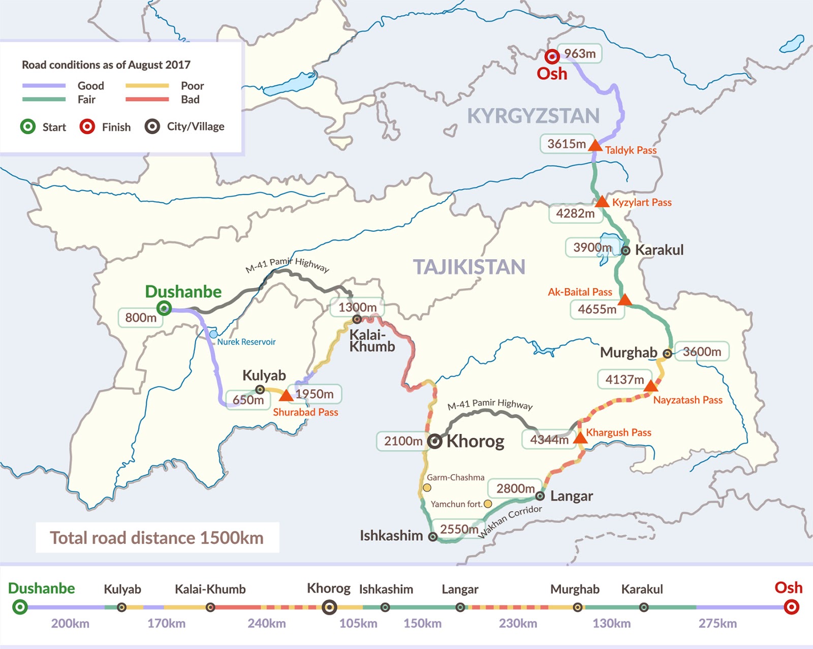
Our goal was to conquer the highway. We were considering taking our bikes, but my friend was not as fit as I was, so we ditched the idea and rented a car instead. As the only option was to do it in Kyrgyzstan (I'll talk about that in two weeks) and we also needed to return it there, a loop was inevitable. Thus from Osh, we headed south to Sary-Tash, the last inhabited place before the border with Tajikistan. We continued through Kyzylart Pass to Murghab and then when the M-41 splits we took a left turn towards the Afghan border, crossed the Khargush Pass and descended to the lush valley along the Panj river (Hojancha commenting: "This sounds so Attenborough-ish"). After visiting Ishkashim and Khorog we took the M-41 again and returned all the way back. And to answer your question, no, I did not memorize all those names, I had to google it now to be able to write this, but there's nothing I would not do for you, our dear readers ;).
Our route didn't match exactly the M-41 (Pamir Highway) as you can see from the picture above. The reason we planned it differently was that we wanted to drive along the Panj river which separates Tajikistan and the Wakhan Corridor in Afghanistan (Hojancha commenting: "cause it sounds really badass" :D). It is also one of the most impressive parts of the road as you get to see not only the Pamir mountains but also the magnificent peaks of the Hindu Kush mountain range in Pakistan.
Some basic details that I want to share with you.
duration: 8 days
season: early summer
car: Ford Ranger 4x4 manual
roads: in bad (and worse and some in terrible) conditions
total length: ca. 1600 km
solitude level: max possible
altitudes: expect some headache and dizziness above 3500m (50% true, I was fine pretty much the whole time)
coverage GSM: almost nowhere (except for cities), so yeah, you'll be off the grid when it comes to facebook and twitter
coverage Satellite: Iridium does well (thank god :D)
I hope I got you interested :) and that you are looking forward to reading my next post in two weeks time. I am going to write more in detail about the first part of the trip - Osh to Kyzylart Pass.
Part 2 - From Osh to Kyzylart Pass
Part 3 - From Kyzylart Pass to Murghab
Part 4 - From Murghab to Ishkashim
Part 5 - Back to Osh (via Khorog)
Our goal was to conquer the highway. We were considering taking our bikes, but my friend was not as fit as I was, so we ditched the idea and rented a car instead. As the only option was to do it in Kyrgyzstan (I'll talk about that in two weeks) and we also needed to return it there, a loop was inevitable. Thus from Osh, we headed south to Sary-Tash, the last inhabited place before the border with Tajikistan. We continued through Kyzylart Pass to Murghab and then when the M-41 splits we took a left turn towards the Afghan border, crossed the Khargush Pass and descended to the lush valley along the Panj river (Hojancha commenting: "This sounds so Attenborough-ish"). After visiting Ishkashim and Khorog we took the M-41 again and returned all the way back. And to answer your question, no, I did not memorize all those names, I had to google it now to be able to write this, but there's nothing I would not do for you, our dear readers ;).
 |
| This map is courtesy of Advantour.com |
Our route didn't match exactly the M-41 (Pamir Highway) as you can see from the picture above. The reason we planned it differently was that we wanted to drive along the Panj river which separates Tajikistan and the Wakhan Corridor in Afghanistan (Hojancha commenting: "cause it sounds really badass" :D). It is also one of the most impressive parts of the road as you get to see not only the Pamir mountains but also the magnificent peaks of the Hindu Kush mountain range in Pakistan.
Some basic details that I want to share with you.
duration: 8 days
season: early summer
car: Ford Ranger 4x4 manual
roads: in bad (and worse and some in terrible) conditions
total length: ca. 1600 km
solitude level: max possible
altitudes: expect some headache and dizziness above 3500m (50% true, I was fine pretty much the whole time)
coverage GSM: almost nowhere (except for cities), so yeah, you'll be off the grid when it comes to facebook and twitter
coverage Satellite: Iridium does well (thank god :D)
I hope I got you interested :) and that you are looking forward to reading my next post in two weeks time. I am going to write more in detail about the first part of the trip - Osh to Kyzylart Pass.
Part 2 - From Osh to Kyzylart Pass
Part 3 - From Kyzylart Pass to Murghab
Part 4 - From Murghab to Ishkashim
Part 5 - Back to Osh (via Khorog)